The Metro 2040 plan calls for building minimal new freeways and other highways in the Portland area. Question: What urban area has the lowest number of miles of freeway per person in the U.S.? Answer: Los Angeles.
The Metro 2040 plan calls for building an expensive light-rail network. Question: What urban area is building the most expensive light-rail system in the U.S.? Answer: Los Angeles.
Portlanders agree that the last thing they want is for Portland to become like Los Angeles. Question: What urban area does Metro say that it "desires to replicate"? Answer: LOS ANGELES.
How can Los Angeles be Metro's goal for Portland? The answer is that Metro has fooled itself into thinking that the very things that make Los Angeles so congested and polluted will somehow make Portland more livable.
The truth is exactly the opposite. Higher densities inevitably increase auto traffic. Even if higher densities lead a few more people to walk or use transit, this doesn't make up for the increased traffic generated by more people in a given area.
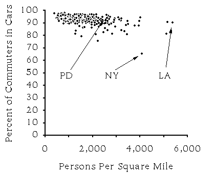
Figure one: About 90 percent of Americans drive to work no matter how dense their city. Source: Census Bureau data for nearly 300 cities.
To bolster its claim that higher densities can reduce congestion, Metro
compares population densities of various urban areas with the share of
commuters using automobiles. But, as figure one shows, the results are
inconclusive. With the exception of New York urban area (which includes
northern New Jersey), the share of auto usage is around 90 percent no matter
what the population density.
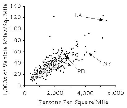
Figure two: Higher densities clearly lead to more total driving in an urban area.
Even if there were a correlation, the share of commuters who drive is
not a measure of congestion. A better measure of potential congestion is the
number of miles autos are driven (known to planners as "vehicle miles traveled"
or VMTs) each day on each square mile of land. Figure two shows a strong
correlation between the VMTs per square mile and the population density.
Higher population densities inevitably lead to more vehicle miles traveled. Even New York, which has the lowest share of auto commuters in the country, has far more vehicle miles traveled per square mile than most other cities with lower population densities.
Los Angeles has terrible congestion because it combines the highest population density of any U.S. urban area--5,600 people per square mile in 1990 compared with only 4,100 in the New York area--with the fewest number of miles of freeway per capita. The high population produces by far the most vehicle miles traveled per square mile of any major U.S. city. Yet with so few freeways per capita, those cars get jammed in daily congestion.
The Portland area's 1990 density was only about 2,800 per square mile, but the 2040 plan would increase it to 5,000 people per square mile--more like Los Angeles and even denser than the New York area. Portland currently has more than twice as many miles of freeway per capita than Los Angeles, but the 2040 plan would reduce this to only about a third more than LA.
Metro's own computer models predict that the 2040 plan will quadruple Portland-area congestion. Metro says that Portland had 162 miles of congested roads during a typical peak rush hour in 1990, and predicts that this will increase to 620 miles under the 2040 plan. Since the number of hours of congestion per day will also increase, total congestion will more than quadruple.
Metro says that the 2040 plan is better because, even though congestion quadruples over today, it has less congestion than the other alternatives Metro considered. But those alternatives all assumed even fewer new lane-miles of roads than the 2040 plan.
Is this cost worth it? Not if the goal is to reduce congestion. Los Angeles is building the most expensive light-rail system in the world, but the cost of the light rail is forcing the transit agency to reduce bus service. These reductions will more than the gain that Los Angeles transit experts expect from new light rail riders.
The same thing is likely to happen in Portland. According to Metro's Regional Transportation Plan, just the cost of operating the south-north light-rail line "limits future bus expansion" to around 1 percent per year--less than the population growth rate. If the south-north line is not built, funds will be available to expand the bus system much faster than the population growth rate.
John Fregonese, Metro's top growth planner, admits that light rail "is not worth the cost if you are just looking at transit. It's a way to develop your community at higher densities." But if higher densities merely increase congestion, then why would we want them?
The document notes that in "the LA region, we find high densities and low per capita road and freeway mileage." Metro goes on to say that "In public discussions we gather the general impression that Los Angeles represents a future to be avoided." Yet, says Metro, "with respect to density and road per capita mileage it displays an investment pattern we desire to replicate" (emphasis added).
Is this because Metro really believes that high population densities and low road mileages will reduce congestion? No. While transportation planners normally attempt to reduce congestion, another Metro document says that it has the opposite goal.
"The 2040 Growth Concept requires a departure from past transportation planning practice," says Metro's Regional Transportation Plan Update of March, 1996. While Metro wants to keep congestion low in industrial areas, it says that increased congestion in many residential and commercial areas will "signal positive urban development for those areas." In other words, congestion is Metro's goal, not something to be avoided.
Does Metro think that this congestion will get people out of their cars and onto mass transit? Not really. According to Metro, less than 2.2 percent of Portland-area trips in 1990 were by mass transit, while 93 percent were by car (the rest were walking or bicycling). After the 2040 plan is imposed on Portland, Metro predicts that transit use will stay under 5 percent while auto use remains around 90 percent--not a huge difference, and certainly not one worth all of the cost of the 2040 plan.
If you want to save Portland from turning into Los Angeles, then you need to tell Metro and your local city council or county commission that you oppose higher densities and light rail. Only your actions now can stop Metro from destroying Portland's livability tomorrow.
Metro, Region 2040 Recommended Alternative Technical Appendix, September 1994 (1990 numbers and 2040 predictions for vehicle miles traveled, lane miles, miles of congested roads, share of trips using transit, etc.).
Metro, Regional Transportation Plan, July 1995, p. 7-8 (light rail "limits future bus expansion").
Metro, Regional Transportation Plan Update, March 1996, p. 1-20 (congestion "signals positive urban development").
U.S. Census Bureau, 1990 Census of Population and Housing, 1992 (data for figures one and two).
Wisconsin State Journal, 23 July 1995 (Fregonese quote).
Note: All references to Los Angeles, New York, Portland, and other urban areas refer to the greater metropolitan areas, not just the named central cities.
This fact sheet was prepared by the Thoreau Institute for ORTEM, a citizens' group opposed to the Metro 2040 plan. Fact sheets are available on a variety of other topics, including congestion, growth, and open space. If you have any questions or would like more copies of this fact sheet, please call or write the Thoreau Institute, 14417 S.E. Laurie, Oak Grove, Oregon 97267, 652-7049, or email rot@ti.org.